Over a few weeks, RoadBikeRider listed several ways to do map bike rides in their newsletter. They first mentioned MapMyRun. Readers then sent them better ways to map for cycling. I know my friend always sends me links to MotionBased when he does big rides.
I’m really not a gadget kind of guy. I don’t have a GPS unit other than the one given to me for Race Across America. It doesn’t have an interface and has to be used with mapping software on a computer.
I don’t have any computer on my mountain bike and for a long time I didn’t even have one on my road bike. In 2002 when I started riding more on the road and getting ready for my first RAAM qualifier, I started doing the UMCA Mileage Challenge. Now it’s called the UMCA Year-Rounder Challenge. One of the ways to submit personal rides is to use a downloadable computer. I got the downloadable CM414 which has an altimeter so I can see the profile of my rides.
One of the things I’ve been concerned about with GPS units is that I hear they typically only have a 10 hour battery life. I’ve heard that at least on some of them you can swap batteries and not lose the current route so maybe that’s an option. Another reason has been that I didn’t want to spend the money. I figured in another year I’d get something better for less money. Now I’m thinking they might be getting close to something I’d pay for. If you use a GPS, what do you like or not like about yours?
Here’s the ways to use GPS to map rides that RoadBikeRider readers sent in.
TopoRoute doesn’t require clicking multiple times to go around a curve. It has logic to follow the road. For bike paths and shortcuts that aren’t roads, it allows you to “not follow the road.” It also has an elevation feature. You can even create a link to your route and e-mail it to friends. — Kurt J.
Bikely uses Google maps. It’s got some great features including an elevation chart. I’ve been using it for years. — Cory B.
MapMyRide lets riders save their routes and e-mail them to friends or post them on the Map My Ride website for access by the internet community. This could be a good source for finding a decent route when visiting an unfamiliar area. A route can be uploaded to Google Earth to overlay it there. — Bob B. www.mapmyride.com has a “follow roads” option where you don’t have to put lots of points around curves to get accurate results. — Mike E.
VeloRoutes offers GPX and Google Earth export plus auto-routing, a feature that makes the route lines “snap” to the road. — Matt M., veloroutes creator
RouteSlip has many routes mapped out and also includes elevation profiles. — Tracy G.
CyclistNexus is very much a work in progress but there are some awesome features. You can track weekly mileage, favorite routes, weekly elevation gain and heart rate info. Plus you can plan out events and group rides. Keep an eye on it. — Tim A.
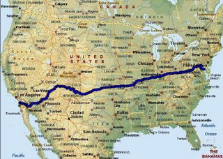
Google Maps. I like Google maps. They can automatically follow the corners for you. Google also gives turn-by-turn written directions for those who are map-reading challenged. Unfortunately the time estimates are off since it assumes you will be traveling at the speed limit. It also doesn’t give you an elevation profile. Here’s the route of a recent 78.5-km ride. — Michael N.
Gmaps Pedometer can use a hybrid view of satellite with street names. When your trusted Cateye computer is on the fritz then you can count on this site to count your miles. — Bob S.
These were sent in (with comments) by Rob A. of Webster Groves, Missouri.
- RouteSaver. An application that can be used to save any of kind of running, cycling or other route. The tool is based on the new interface that Google has provided for its Google Maps program.
- MotionBased is a web application that translates GPS data into functional analysis and online mapping for athletes. Affiliated with the Garmin GPS company.
- My favorite is Trimble AllSport GPS. It’s designed to run on GPS-enabled cell phones and in web browsers, combining global positioning technology and mobile communications. It’s free and works great with my Garmin Forerunner 301. Here’s an example ride.
Fernando M. also wrote to them and said, “I’m surprised no one offered up Bike Route Toaster as one of the best mapping sites out there. It allows you to download in numerous formats and even saves your rides online.


 Blog RSS Feed
 Like on Facebook
 Follow on Twitter
 Flickr
 Contact
