Exploring the Grand Canyon with Google Street View

February 1st, 2013

Grand Canyon Street View

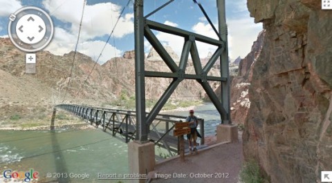
Back in October Google had posted on their blog that they had a team hiking in the Grand Canyon to get imagery for Street View. I figured they were just doing a couple of the main trails. They now have 75 miles of trails and surrounding roads live in Google Maps.

The Google team their Android-operated Trekkers to take the imagery. They carried 40-pound backpacks with the 15-lens camera system. More than 9,500 panoramas are now available on Google Maps.

In 2006 and 2008 I did week long backpacking trips in the Grand Canyon. I went west farther than most people go for the first trip. The trail was hard to find and I didn’t see anyone for 3 days. The 2nd trip I hiked the eastern part of the Grand Canyon and even went a little east of where the National Park ends.

I can tell you there’s no way to comprehend the size of the canyon looking at a computer screen. Still I have to say what Google has done is pretty cool.

Some cool places to check out are the bridge across the Colorado River to Phantom Canyon, Bright Angel Trail, South Kaibab Trail and the Meteor Crater. Maybe those will motivate you to take an adventure of your own in the Grand Canyon.

Asolo TPS 520 GV Evo Hiking Boots
Price: $268.44
 
Scarpa Zen Pro Mid GTX Hiking Boots
Price: $159.94
 
Hi Tec Penrith Mid Jr. WP Hiking Boots
Price: $38.73
 

Google Maps Now for Biking

March 12th, 2010

Earlier this week Google added a Bicycling option to directions in Google Maps. Now in addition to getting directions By Car, By public transit and Walking, you can select Bicycling from the drop down below the 2 locations. Bike paths are shown in solid green and recommended bike routes on streets are shown as dotted green lines.

I used it to get directions between my house and work. Except for a couple blocks, I can ride the whole way on bike paths. Google had most of the bike paths but they missed a key section. Because of that they ended up using a couple blocks of a busy street. It was still the best route without using the missing bike path.

From my house to work it is all uphill and obviously downhill on the way to home. I was happy to see that they do take elevation into account in their estimated time for bikes. They showed it taking 27 minutes to get to work and 18 minutes to get home. I ride a little faster than that but those are reasonable estimates.

As another test, I checked from my house to my parents house. It choose a busy street up a 9% grade hill instead of a much flatter route on quiet streets. The route I take is slightly longer but much safer and easier. I don’t find it surprising that they wouldn’t be able to find the best bike route. I’d just caution you to use the bike directions as a guide and not totally rely on on them.

To promote the new feature, Google is giving a $2,500 voucher to one lucky Twitter user. One winner will be randomly selected to receive a voucher for $2,500 USD to be used at American Cyclery. Entries must be received through a tweet which includes the hashtag #bikewithgoogle by 12 PM PST on March 19, 2010. See official rules for more details.

UltraRob

Asolo TPS 520 GV Evo Hiking Boots
Price: $268.44
 
Scarpa Zen Pro Mid GTX Hiking Boots
Price: $159.94
 
Hi Tec Penrith Mid Jr. WP Hiking Boots
Price: $38.73


Email: web@ultrarob.com

Business Seal       Privacy Seal